Contents
Index
Parcel Closure Report
This report uses the measured distances and bearings of each lot to compute the misclose.
The misclose is then distributed by a Bowditch adjustment and the lot area is calculated.
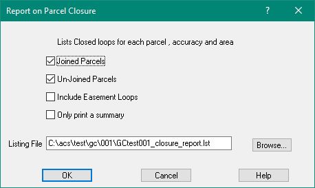
Joined Parcels
Tick to include Joined parcels in the report
Unjoined Parcels
Tick to include Unjoined parcels in the report
Include Easement Loops
Tick to include Easements in the report
Only Print a Summary
If this is ticked, the following information will be printed for each lot"
Lot=45 Plan=752459 Rounded Area=125a0r27.26p, Raw Area=506546.640 Sqm
Misc Bearing 347°26'41" Dist 0.134 Acc 1/28238 Perimeter 3505.553
Listing File
Enter the name of the listing file
Parcels with True Mid Bearings
True mid bearings will be adjusted if:
1. The job Datum and Zone are setup.
2. The job centroid has been set up.
3. The "Mid Brgs" box is ticked in the Plan section of the Parcel properties menu.
The convergence for each True Mid Bearing is calculated on a line by line basis.
If the lot is joined and on a geodetic coordinate system, the starting coordinate is that of the first point in the close.
If the lot is unjoined or the job is on a "local" coordinate system, the job centroid (in job settings) is the starting coordinate.
As each parcel line is processed it calculates the end point approximately first.
It then uses the coordinates of the start and end points of that line to get the convergence using the full geodetic formula.
It then recalculates the end point of the line using the calculated true mid correction.
Setting the Job Centroid
If the job has control points, the job centroid will be determined from the control point coordinates.
If it is a new job, or does not have any control points, the centroid can be entered
with Job Settings.
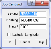
Select "Job Settings" from the file menu.
Press the "Set Job Centroid" button and the Job centroid dialogue will pop up.
If a centroid exists its coordinates will be displayed.
If the "Latitude/Longitude" box is ticked, the centroid data can be entered as a Latitude and Longitude.